|
The Seven Heads Walks booklet can be purchased in most retailers and newsagents in the West Cork area. The booklet details the various walking routes that extend from Timoleague village through Courtmacsherry, around the rugged cliffs and shore line to Dunworley and on through Barrryscove and Ardgehane to Aghafore and Barryshall and then back to Timoleague. It also provides the reader with a detailed history of the area and the various flora and fauna to watch out for while on the route.
The extract below gives a brief taste of the content included in the Seven Heads booklet
"Ramsey Hill, Melmane, Broadstrand, Barry's Point
The road to the left passes Hill Top Cottage and starts to descend towards Broadstrand Bay ahead.To the left can be seen the Old Head of Kinsale and Garrettstown Wood. The road leads on past the Caravan Park on the left to Melmane Village. This is a collection of eight low houses whose rooflines follow the fall of the road rather than the horizontal. This unique feature was probably a local solution to maintaining a thatch roof against the open southwesterly aspect. Angled thus the roof threw off the wind rather than the wind throwing off the roof. In 1841 Melmane (which means Middle Hill) had 954 people to the
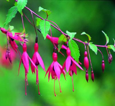
square mile.The road now is a dead-end due to coastal erosion, but we take a right at the second last double house on the left and enter an ancient hidden walkway between hedges of Fuchsia, Escalonia, Whitethorn and Blackthorn. We emerge via a stone wicket and cross two fields towards Broadstrand which curves away to our left. The beach is sandy with shingle and rounded stones at high-water mark. With a spring tide and an easterly wind those stones can be heard ‘growling’ as far away as Butlerstown. It is a safe and clean bathing beach and is very sheltered in southwesterly winds. It offers excellent bass
fishing and in August the odd run of mackerel add to the fun.
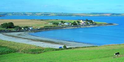
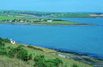
Blind Strand with Coolbawn in the background
At the southern end we cross a stream and walk for about 200 metres under the yellow clay cliff to where steps take us up to join the old road that once linked up with Melmane Village before being eroded by the relentless tide. We emerge on to the Lislee Court Road and continue southwards past a brightly painted cottage called Gulls Nest. At the foot of the hill the road swings left to the little fishing hamlet of Coolbaun and Blind Strand. Coolbaun was once densely populated and had a busy slate quarry. It was also the site of Lislee Castle now gone without a trace. We ignore the left turn and continue straight ahead across two fields picking up a cow path. The path climbs steeply. The old stone wall on our right is part of the boundary of Lislee Court. We emerge on to the Barry’s Point road by an old stone stile under a sycamore tree. Here we can rest a moment after the climb and admire the view of Coolbaun, Blind Strand and the inner bay with Coolmain and Garrettstown strands in the distance. We now turn left and walk towards Barry’s Point. As a small detour we walk eastwards.The flat silver sands of Blind Strand are on our left below. This sheltered strand had its sea wall shattered in a storm in December 1989.
The road swings left and downhill after passing a farmhouse and shed on our left. We continue through a farmyard and pick up a grassy bohereen ahead. On our left is a small two-roomed house whose roofline follows the slope of the ground as in Melmane. It has one large and one small chimney. It would be nice to see such charmingly eccentric features sensitively reserved. Dog roses mark what once was the back garden. As we walk eastwards we see on our left ahead the site of the old Lifeboat Station. This is now private property so be sensitive in your approach. The concrete and timber piles remain where they were cut off at ground level, the jarrah wood retaining a faint red colour. It was from here, on the 7th May 1915, that the lifeboat was launched to go to the aid of the Lusitania. On that day the rescue operation was hampered by lack of wind. The twelve miles were covered by rowing and the journey took three hours. The Trent Class Lifeboat now in Courtmacsherry would make the journey in 20 minutes. A noted coxswain was Timothy Keohane of Coolbawn, whose son Patrick went to within 150 miles of the South Pole during the 1910-12 Scott Expedition. (see p 26).
Old Lifeboat Station at Barry’s Point and Coolbawn village.
We now admire the view of Courtmacsherry Bay. On our left Coolbawn and Quarry Point with Broadstrand hidden behind them. We pick out Wood Point and its beacon with Coolmaine beach and castle in the background. The lane continues to a gate with a notice forbidding unauthorised entry. Any further progress would have to be in consultation with the landowner. But a word of caution: The tip of Barr y’s Point has razor sharp rocks where even a small fall could have nasty consequences. It is as well left unexplored by the casual walker. We return by the same route and pick up an ancient bohereen on our left, 200 metres east of where we emerged into the Barr y’s Point road."
|